The India Meteorological Department’s forecast for the south-west monsoon onset over Kerala on Thursday shifts earnings visibility for agriculture-linked and power-sector stocks. For Tamil Nadu, Puducherry and Karaikal, the immediate consequence is isolated to scattered light-to-moderate rainfall with thunderstorms, lightning and gusty winds of 40-50 km/hr. That is direct relief from heat that has pushed maximum temperatures 3°C above normal across the region.
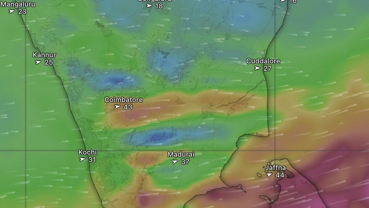
That relief matters for earnings. Sustained heat above 40°C raises cooling demand, strains power grids, and dries soil moisture for the rabi and early kharif crops. The source data shows Khammam in Telangana recorded the country’s highest maximum temperature at 43°C on Tuesday. Chennai, Vellore and Madurai had already hit 34°C by 10 am on Wednesday. A monsoon arrival next door changes the demand and cost assumptions baked into current consensus estimates for several sectors.
Monsoon Onset and the Sector Earnings Read-Through
The monsoon’s progress is visible in surface wind data: westerly winds up to 43 km/hr from Thiruvananthapuram to Nagercoil, turning westerly along the Kerala coast and south-westerly from Udupi northward across coastal Karnataka, Goa and the Konkan-Mumbai belt. These are not abstract meteorological details. For companies with exposure to agricultural inputs – fertilisers, pesticides, seeds, and farm equipment – the monsoon onset is the single most important demand catalyst in the June-September period.
Relief for Tamil Nadu’s Power and Agri Exposure
Tamil Nadu’s power demand typically spikes when temperatures run 3°C above normal. The state’s peak demand in May 2024 crossed 20 GW. A monsoon-driven cooling effect reduces the need for expensive short-term power purchases, improving margins for state-owned distribution companies and lowering fuel costs for thermal generators. For listed power producers with merchant exposure in the southern grid, the margin impact is measurable.
On the agriculture side, the rainfall forecast for Tamil Nadu covers the crucial sowing window for paddy, cotton, and sugarcane. Scattered light-to-moderate rain with thunderstorms is not a drought breaker. It resets soil moisture ahead of the main monsoon trough. Companies like Coromandel International and Chambal Fertilizers (sector read-through, not named in source) typically see inventory builds during this window.
Heat Wave Data Points Quantify Pre-Monsoon Stress
The source provides a temperature snapshot that quantifies the pre-monsoon stress. By 10 am on Wednesday, Chennai, Vellore and Madurai were at 34°C, Cuddalore and Tiruchirappalli at 33°C, Nagapattinam at 32°C. In contrast, most of Kerala remained in the high-20s under expanding monsoon cloud cover. That 5-7°C differential is the earnings risk: companies with operations in Tamil Nadu face higher cooling costs, lower labour productivity, and potential crop loss if the monsoon delays further.
North-West India’s Western Disturbance Cycle Adds Execution Risk
While the monsoon dominates the south, North-West India is dealing with a departing western disturbance that triggered widespread thunderstorms, dust storms, lightning and hail across Rajasthan. A successor system is expected to enter later Wednesday. The European Centre for Medium-Range Weather Forecasts projects thunderstorms over Kota in south-east Rajasthan and Indore in Madhya Pradesh on Wednesday, with intensification on Thursday extending to Shimla and New Delhi.
For companies with supply chains or warehouses in these regions – particularly in logistics, cold storage, and perishable goods – the storm cycle creates execution risk. Hail can damage standing crops. Dust storms disrupt transport. The source notes that by Friday, thunderstorms are forecast over Jaipur, Uttarakhand, Bareilly, Banda, Damoh, Chhindwara, Jalgaon, Akola, Nagpur, and even Hyderabad. That is a wide geographic footprint.
Supply Chain Disruption Risk for Manufacturing Plants
Companies with manufacturing plants in Rajasthan, Madhya Pradesh, and Maharashtra face production halts and inventory damage from hail, lightning, and dust storms. The source’s satellite imagery also shows cloud patches over Raipur in Chhattisgarh and Prayagraj in Uttar Pradesh, indicating the disturbance’s reach.
Practical rule: When a monsoon onset is confirmed by wind data and satellite imagery, the first derivative is agri-input stocks. The second derivative is power-sector stocks in the southern grid. The third derivative is consumer staples exposed to rural demand.
Valuation Context and the Monsoon Premium
Seasonal weather events rarely get a standalone valuation line. The market prices them through implied volatility in agri-commodity futures and through earnings revisions for exposed sectors. A timely monsoon onset typically compresses the risk premium for fertiliser and tractor stocks. A delay expands it.
What Confirms or Weakens the Thesis
- Confirmation: Widespread rainfall over Tamil Nadu within the next 72 hours, combined with the monsoon’s advance along the west coast as shown in satellite imagery (cloud bands over Mangaluru, Kundapura, Shivamogga, advancing toward Goa, Konkan, Mumbai, and inland across Sangli, Solapur, Nanded).
- Weakening: If the monsoon stalls after the Kerala onset and the heat wave returns, the earnings relief narrative reverses. The source shows largely cloud-free skies over Tamil Nadu on Wednesday morning, so the window is narrow.
Monsoon Catalyst Path for Agri and Power Stocks
The monsoon onset over Kerala on Thursday is not a market-moving event by itself. The combination of a heat wave in Tamil Nadu, a western disturbance cycle in North-West India, and the specific temperature and wind data from the source creates a tradable setup for agri and power stocks. The key is to watch the rainfall realisation over Tamil Nadu and the intensity of the successor western disturbance. If both confirm the pattern, the earnings revision cycle for exposed sectors should begin within the next two weeks.
For a broader view of how seasonal weather patterns affect sector-level earnings, see our stock market analysis and the brokerage upgrades cluster on cash-rich tech and healthcare.