The monsoon depression closes the rainfall deficit by 17 points in a week. A western disturbance coupling raises flood risk for Gujarat and Madhya Pradesh crops.
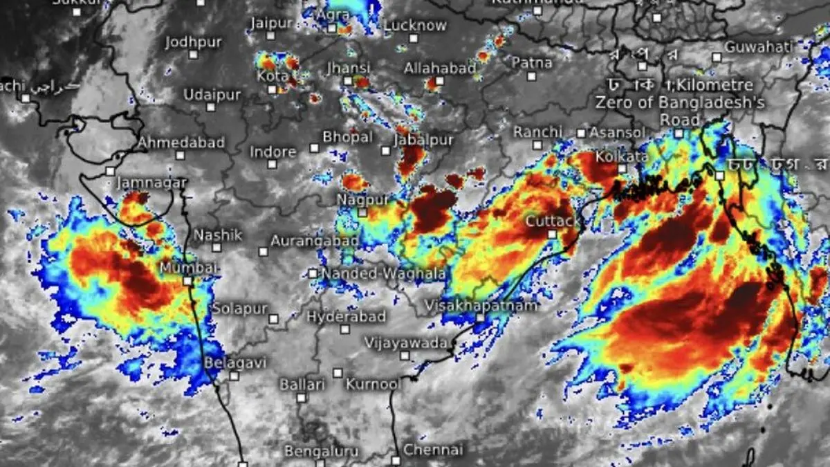
The monsoon depression that formed over the north-west Bay of Bengal crossed the north Odisha coast near Balasore on Monday, setting up a week-long siege of heavy to very heavy rain across Odisha, West Bengal and Chhattisgarh. The India Meteorological Department (IMD) expects the system to move slowly inland, drawing moisture from the Bay and feeding the monsoon trough through the week.
The rain revival has already made a dramatic dent in the seasonal shortfall. The rainfall deficit over the monsoon core zone of Central India shrank by nearly 17 percentage points in less than a week to 23 percent below normal. The all-India deficit narrowed by 13 points to 27 percent below normal. The gap is expected to close further in coming days, the IMD said.
For Kharif sowing, the widespread moisture supports soybean, cotton and groundnut planting in Madhya Pradesh, Gujarat and Maharashtra. Soil moisture conditions improved sharply across the core zone. The bullish case for a normal or above-normal harvest rests on this week's pattern holding through the rest of the season.
The better read involves the western disturbance. Weather models show the depression may weaken inland before interacting with an approaching western disturbance. That rare east-west coupling could unleash another round of heavy rain over already waterlogged parts of West Madhya Pradesh, Gujarat and the Konkan, including Mumbai. The pounding is expected to last until Thursday, the IMD said.
The flood risk is real for standing crops in those regions. Cotton and groundnut in Gujarat, soybean in Madhya Pradesh are at a vulnerable stage. Heavy rain and waterlogging in the first week of July can damage root systems and delay or reduce yields. Traders tracking NCDEX futures will watch for damage reports from these belts in coming days.
After this week, the rain belt is forecast to shift north toward the Himalayan foothills. Central India may see only scattered, incidental showers after that. The deficit that narrowed this week could build again over parts of the region if the drying period extends. The bullish case for Kharif output based on this week's rain may be premature. The monsoon has been erratic this season. This depression is a powerful corrective, not yet a trend.
The IMD said conditions remain favourable for the monsoon to advance into remaining parts of Haryana, Punjab and more of Rajasthan over the next four days. After that, the focus shifts to the North-East, Bihar, Uttar Pradesh, Uttarakhand, Himachal Pradesh and Jammu-Kashmir-Ladakh. For traders, the key variable is whether the western disturbance produces crop damage in Gujarat and Madhya Pradesh, and how quickly the deficit rebuilds in Central India after the rain belt moves north.
Prepared with AlphaScala editorial tooling from the source reporting linked above. Indexable analysis may include a cited Alpha Score value. Publishing checks screen each story before release. Educational coverage, not personalized advice.