A fresh low-pressure area formed over the north-west Bay of Bengal on Sunday, extending a chain of tropical disturbances. The IMD has issued a six-day heavy rainfall outlook across many states.
A fresh low-pressure area formed over the north-west Bay of Bengal on Sunday, extending what is shaping up as an unbroken chain of tropical disturbances feeding into India's monsoon trough. The system sits at the downstream end of a conveyor belt running deep into the western Pacific.
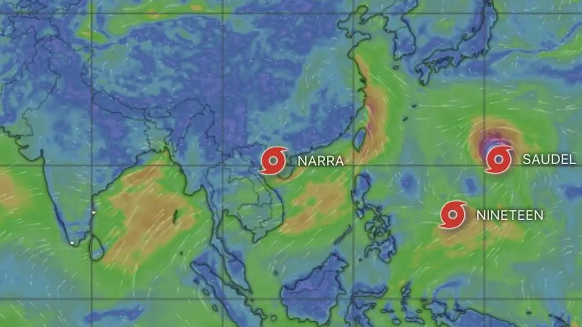
Satellite imagery Sunday morning showed three tropical systems arranged across that basin. Typhoon Saudel headed toward the east China coast. Tropical Storm Narra lingered off Vietnam. Tropical Depression 19 spun east of the Philippines. All three have tracks with a westerly or north-westerly component, the kind of movement that sends waves of atmospheric energy across Indochina and into the Bay, where the monsoon circulation can give them a second life.
The immediate suspect behind the new Bay low is Narra. Forecast to hover near the Vietnam coast until Wednesday, it could help shepherd further inbound circulations through the coming week, the India Meteorological Department said. Saudel briefly showed ambitions of becoming a category-5 super typhoon over the central Pacific before weakening to a category 3 on approach toward the Taipei-east China coast sector. Its associated atmospheric pulse also contributed.
The larger backdrop is a Pacific that remains exceptionally warm. The heat, associated in part with the El Niño pattern in the equatorial and eastern Pacific near the South American coast, has extended across the central Pacific and deep into the western Pacific, which appeared particularly warm on Sunday. Farther west, sea-surface temperatures have cooled closer to the east China coast, a likely factor in Saudel's weakening as it nears land.
The monsoon trough Sunday morning stretched from Ferozpur through Karnal, Bareilly, Lucknow and Ranchi, then passed through the centre of the new low over the north-west Bay and ran south-eastward into the east-central Bay. That alignment leaves the door open for disturbances arriving from across Indochina to plug directly into the monsoon circulation. A predecessor low over north-east Madhya Pradesh, which has been carrying much of the monsoon workload in recent days, has weakened and ceded centre stage to the newborn Bay system.
A secondary trough adds another layer, extending from the cyclonic circulation associated with the Bay low toward east Uttar Pradesh through Jharkhand and north Chhattisgarh. A western disturbance lay as a trough from central-east Iran toward the Afghanistan border, while an upper-air cyclonic circulation occupied the region over north Haryana. The wider weather map is busy, with several moving parts and plenty of moisture and instability available for rainfall.
The IMD has responded with a broad and unusually prolonged rainfall outlook. Odisha is in line for isolated very heavy rain on each of the next six days. Chhattisgarh could see isolated very heavy rain on Sunday. Across the north-east, Arunachal Pradesh, Assam and Meghalaya, Nagaland, Manipur, Mizoram and Tripura are all expected to receive isolated heavy rainfall at times through the next six days.
Tamil Nadu, Puducherry and Karaikal in the South Peninsula could see isolated heavy rain on Monday and Tuesday. Kerala and Mahe, along with Telangana, are likely to receive isolated heavy rain for three days from Sunday. Coastal Karnataka and South Interior Karnataka are expected to see heavy rain on Sunday and Monday, while Coastal Andhra Pradesh faces the prospect of isolated very heavy rain on Sunday. For the next six days, isolated to scattered rainfall is expected over Coastal Andhra Pradesh and Yanam, Rayalaseema, Tamil Nadu, Puducherry and Karaikal, and Telangana. North Interior Karnataka and South Interior Karnataka could see similar conditions for three days from Tuesday.
The wettest belt is likely to remain along the western side of the peninsula. Fairly widespread to widespread rain is forecast over Coastal Karnataka, Kerala and Mahe, and Lakshadweep through the next six days, with North Interior Karnataka and South Interior Karnataka also seeing widespread rain for two days.
Central India will not escape the passing disturbance. West Madhya Pradesh is expected to receive isolated heavy rainfall for three days from Sunday, East Madhya Pradesh for four days, Vidarbha on Sunday and Monday, and Chhattisgarh for five days from Monday.
Up north, Uttarakhand faces six days of isolated heavy rain. Jammu and Kashmir and Ladakh could see fairly widespread to widespread rainfall on Sunday. Uttarakhand is expected to remain under fairly widespread to widespread rainfall for the next six days.
Prepared with AlphaScala editorial tooling from the source reporting linked above. Indexable analysis may include a cited Alpha Score value. Publishing checks screen each story before release. Educational coverage, not personalized advice.